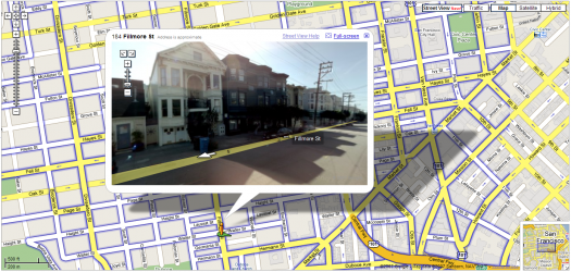
Mara and I just moved into the Lower Haight earlier this month, and Google just released a new Maps feature — Street View — that has a picture of our place. If I weren't writing about this, I'd be speechless. Wow.
 Our place is the yellow two-story walk-up that is bustin out of the top of the frame. I love that it was captured on one of those semi-sunny days where little wisps of fog drift through. So nice to not live in the fog belt. Incidentally, here's the Chronicle's fog forecast. Doesn't look good.
Street Level seems like useful functionality, esp. for fancy mobile devices, which I don't have. The controls are pretty straightforward and easy to use on a desktop, but I wonder about the ease with which one could navigate up and down the streets with those teeny arrows on a Palm or Blackberry. This is really nitpicky, but I think it would be effective to introduce more map navigation into the image, i.e. skipping to the next intersection, returning to the original destination, etc. Future-wise, it would be awesome to be able to do stuff with the images — easily insert them into other things, string them together in connection with directions, etc. What I want to know is: How the heck did they do it? Thx, kottke.
